 |
LexRides
Lexington's Bike Forum
|
| View previous topic :: View next topic |
| Author |
Message |
metro biking
hipster

Joined: 16 Mar 2008
Posts: 64
Location: Lexington, KY
|
 Posted: Thu Nov 17, 2011 12:27 pm Post subject: First Draft Bike Map Mark Up Posted: Thu Nov 17, 2011 12:27 pm Post subject: First Draft Bike Map Mark Up |
 |
|
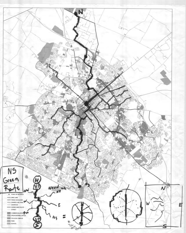
Fellow Lex Bikers – Attempted to attach a scan of the marked up City map we developed at the BPAC Meeting on 11-4.
(Advice please on how to attach files here.)
I am disappointed to report however, that all I have been able to do is have it scanned in black and white as a .pdf file.
Our large format scanner here at work cannot scan color and provides only .pdf, tif or dwf formats – all for raster images. Consequently, when you open the file and zoom in you get bitmap blur at the level showing streets and street names.
Another possibility is to try a tlc file format save; not sure if it is only to scan vector graphics or whether it can convert scan to vector or whether it will make a difference.
I will continue to experiment, unfortunately it will be in black and white.
Also when I get some time I will begin compiling street names for the marked routes but have been too busy to get that underway at this time.
Suggestions for further steps welcome....
Mike G
[/img]
_________________
Metro Biking |
|
| Back to top |
|
 |
brokebike
cutter

Joined: 21 Oct 2007
Posts: 2434
Location: local
|
| Posted: Mon Nov 21, 2011 8:44 am Post subject: |
|
|
_________________
------------[] O |
|
| Back to top |
|
|
metro biking
hipster
Joined: 16 Mar 2008
Posts: 64
Location: Lexington, KY
|
| Posted: Tue Nov 22, 2011 9:56 am Post subject: Notes on the Marked Up Map |
|
|
Thanks 'Bike for posting mark up. As you all can see, this map is limited in its information other than to show rough routing. Heavy NS line represents Legacy Trail from Horse Park into town and south from UK Arboretum on Bellefonte/Lansdowne to Clear Creek and to Veteran's Park. This sort of represents the City's links in the planned regional North South trail (to Georgetown/Scott County and Nicholasville/Jessamine Co. respectively).
You can see the other tentacles leading to other City sectors and I will work on listing those route streets over the Holiday weekend.
It's a start and we will work to get those other connections linked/shown on the on-line Route maps. I will keep everyone posted on developments.
The mapping will an item of business for the Fri. Dec. 2nd 12 noon BPAC meeting. If you have anything to contribute, please plan to attend or send me you ideas off-line so we can continue the process.
Mike
metro_biking @insightbb.com
_________________
Metro Biking |
|
| Back to top |
|
|
roller
d'oh!

Joined: 17 May 2008
Posts: 294
Location: duncan park
|
| Posted: Wed Nov 30, 2011 4:24 pm Post subject: Re: Notes on the Marked Up Map |
|
|
| metro biking wrote: | Thanks 'Bike for posting mark up. As you all can see, this map is limited in its information other than to show rough routing. Heavy NS line represents Legacy Trail from Horse Park into town and south from UK Arboretum on Bellefonte/Lansdowne to Clear Creek and to Veteran's Park. This sort of represents the City's links in the planned regional North South trail (to Georgetown/Scott County and Nicholasville/Jessamine Co. respectively).
You can see the other tentacles leading to other City sectors and I will work on listing those route streets over the Holiday weekend.
It's a start and we will work to get those other connections linked/shown on the on-line Route maps. I will keep everyone posted on developments.
The mapping will an item of business for the Fri. Dec. 2nd 12 noon BPAC meeting. If you have anything to contribute, please plan to attend or send me you ideas off-line so we can continue the process.
Mike
metro_biking @insightbb.com |
I probably won't be able to attend Friday, but I'm still on board with incorporating the committee's preferred routes into my map. This current sketch is not detailed enough to read, but better resolution maps will be available after the next meeting, hopefully. |
|
| Back to top |
|
|
metro biking
hipster
Joined: 16 Mar 2008
Posts: 64
Location: Lexington, KY
|
| Posted: Mon Dec 05, 2011 7:22 pm Post subject: Lexington Biking Routes - Street by Street Descriptions |
|
|
Fellow Cyclists,
Sorry for the delay. but following is the list of biking routes into downtown and the UK and Transy campuses that came off the marked up City map posted here earlier.
I am also forwarding thru the BPAC listserv so meeting attendees can read the route descriptions marked up at the November meeting.
In keeping with usual LexRide forum dialog, trite comments welcome; help getting them onto Roller's bike map linked in this thread even more welcome.
Answers to questions will probably be delayed for a lengthy period as per my style, but write anyway.
Metro Biking
metro_biking@insightbb.com
Lexington Biking Routes
These are representative on-road biking routes concentrating on the spokes to enter the downtown/campus hub. Check the route descriptions against a good City map (left and right turns are not included, for example, only connecting streets). Check the Bike Lexington Bike Map for more information on City biking facilities (go to Bike Lexington web site http://bikelexington.com/resources to view the map).
Route descriptions proceed counter-clockwise from North West Quad (NW) at Horse Park.
NW
From Horse Park:
Legacy Trail to YMCA to E. Loudon Ave.
1. To North Lime to 6th St. to
a. Upper Street to Transy, Downtown
b. MLK Blvd. to Downtown, UK
2. To Shropshire Ave. to Downtown east end.
From Robinson Way at Leestown Rd. (Masterson Sta. Park area)
To Mercer Rd. to Greendale Rd.
To Leestown Rd. to Downtown – caution at Cemeteries, sidewalk available inbound side
OR
1. To Newtown Pike to 3nd St. to Transy
2. To Oliver Lewis Way to Pine St., cross to Maxwell St. to UK.
SW
From Gardenside, Garden Springs, Cardinal Valley
Cardinal Valley, Williamsburg Dr. and Pine Bloom Dr. to Alexandria Dr.
Alexandria Dr. to Beacon Hill Ln.
To Summerville Dr. to Addison Park
From Addison Park:
1. Go right on path
a. Exit Park to Garrison Ave.
b. To Addison Ave. to Devonshire Ave.
c. OR Addison Ave. to Unity Dr. to Red Mile Rd. to Virginia Ave. to S. Lime
d. To Gibson Ave. cross Broadway to left at light
e. To Burley Ave. to Export St. to Virginia Ave. to S. Lime to Campus, Downtown
f. To 3rd St. to Transy
2. Go left on path
a. Exit park and bear right on path on Fayette Co. Extension Service property
b. Thru parking lot to Red Mile Pl.
c. To Red Mile Rd. to Virginia Ave. to S. Lime to UK, Downtown
d. To 3rd St. to Transy
From Beaumont and Stonewall areas:
Exit Beaumont across Harrodsburg Rd. at Wellington Way or Ft. Harrod Dr. to Wellington Way
• Stonewall area to Wellington Way via Cornwall Dr.
Wellington Way to Clays Mill Rd.
• Waveland area - Winthrop Way/Shillito Park area - Boston Rd. to Monticello Blvd. to Clays Mill Rd.
Clays Mill Rd. to Stone Rd. – take the lane over Stone Rd. hill
To South View Dr. to Southland Dr.:
1. To South UK Campus and Downtown/Transy
a. Southland Dr. to Cherrybark Ln.
b. To Rosemont Garden
c. To Hilltonia and thru Central Baptist Hospital Parking Lot (Thanks a lot Central Baptist!)
d. To University Dr. to Huguelet Dr.
e. To Rose St., UK
f. Rose St. to Main St., Downtown
g. Rose St. to 3rd St., Transy
2. To North UK Campus and Downtown/Transy
a. Southland Dr. to Lafayette Pkwy to Springhill Dr.
b. To Clays Mill Rd./ Harrodsburg Rd. to Bob-O-Link Dr. (sidewalk available)
c. To St. Joe Dr./Man o’ War Pl. to American Ave.
Inbound
• American Ave. to Apostolic Way
• To Burley Ave. to Prospect Way/Simpson Ave.
• To Export St.
Outbound
• Export St. to Simpson Ave. to Stillwell Ave. to Burley Ave.
• To Francis Ave. to American Ave.
2. cont. from Export St.
d. To Virginia Ave. to S. Lime to Campus, to Downtown
e. To 3rd St. Transy
S/SE
From Jessamine Co. line at Veteran’s Park:
So. Point Dr. to Clearwater Way
Cross Man ‘o War to Belleau Wood Dr. to Camelot Dr. – Lexington’s First Bike Route!
To Laredo Dr. to Redding Rd. to Lansdowne Dr.
[from Brigadoon Dr., Tartan Dr., Loch Lomond Dr., Wilson Downing Rd. to Lansdowne]
To Bellefonte Rd. to UK Arboretum (ride w/ care on Path and thru property)
To Alumni Dr. SUP to University Dr.
To Huguelet Dr. to Rose St. to UK, Downtown
Rose St. to 3rd St. to Transy
• Link from Pepperhill/Merrick:
Montevesta Rd. to Lansdowne Dr. to Zandale Dr. to Bellefonte Dr. to Arboretum
From Cumberland Hills/Hartland/Kenesaw
Hartland Pkwy. or Rockbridge Rd./Kenesaw Dr.to Hartland Pkwy
To Crosby Dr. to Armstrong Mill Rd. to Greentree Rd.
• OR Armstrong Mill Dr. to Redding Rd. to Lansdowne Dr. to Bellefonte Dr.
Greetree Rd./Chinoe Rd. to Chevy Chase w/ options:
Lakewood Dr. Colony Blvd
Cooper Dr. Tremont Ave.
Hart Rd. to S. Ashland Ave
Fontaine Rd. Euclid Ave.
Fincastle Rd. High St./Central Ave./Old Vine St.
E
Richmond Road Bike Lanes serve Downtown, UK and Transy via:
• Grafton Dr./Squires Rd.
• Pimlico Pkwy./Mt. Tabor Rd.
• Blazer Pkwy./Rio Dosa Dr./Old Todds Rd./Woodhill Dr./Idle Hour area
ALSO:
a. Hayes Blvd. to Todds Rd. to Andover Village Dr.
b. To Forest Hill Dr. to Todds Rd.
c. To Old Todds Rd. to Woodhilll Dr. and via Lexington Mall site.
NE
Eastland Pkwy. via Fortune Dr.
1. Liberty Rd., Stonewood Ln., Haddon Dr. to Fortune Dr.
2. To Winchester Rd. cross to Eastland Pkwy. and via Jennifer Rd.
3. Eastland Pkwy. to E. Loudon Ave.
a. Shropshire Ave. to Midland Ave. to east-side Downtown
b. N. Lime to 6th St.
• 6th to MLK Blvd. Downtown and UK
• 6th to Upper St. to Transy and Downtown
Anniston Dr. to:
• Eastland Pkwy.
• Brynell Dr., Bryanwood Pkwy., Shaftsbury Rd., Meadow Ln.
• Bryan Station Rd., Bryan Ave.
to E. Loudon Ave. (see NE 3.a. and 3.b. above)
If commuting curious, map your route, then have someone drive the route inbound and outbound so you can observe conditions during times of traffic. Ride the route on a Sunday morning for on-road experience during slow traffic period.
Good luck, be careful, have fun.
_________________
Metro Biking |
|
| Back to top |
|
|
|
|
You cannot post new topics in this forum
You cannot reply to topics in this forum
You cannot edit your posts in this forum
You cannot delete your posts in this forum
You cannot vote in polls in this forum
|
Powered by phpBB © 2001, 2005 phpBB Group
|

